• Home
  • Most Popular
  • Submit
  • About Us
  • Contact Us

Softpile

Free Downloads

Categories
  • Home
  • Most Popular
  • Communications
  • Desktop
  • Games & Entertainment
  • Graphic Apps
  • Network & Internet
  • Security & Privacy
  • System Utilities
Database Tour 11.4.5.809
Database Tour is a powerful software that simplifies database management. With features like viewing, editing, and ...
Exportizer 10.1.3.590
Exportizer is a simple and efficient software that enables users to quickly and easily export database ...
MS Access to MySQL Conversion Tool 4.0.6.5
MS Access to MySQL database migration software converts table structures attributes null values relationships with all ...
MySQL DB to MSSQL Migration Tool 4.0.3.2
Distributed database conversion program enables you to transform entire or selected source db tables (MySQL) to ...
MSSQL to MySQL Conversion Program 6.0.7.6
MSSQL to MySQL conversion software is a program used to convert entire or selected MSSQL database ...
Salesforce ODBC Driver by Devart 3.4.3
Devart ODBC Driver for Salesforce is a high-performance software that enables ODBC-compliant tools to efficiently access ...
HubSpot ODBC Driver by Devart 2.2.1
Devart's ODBC Driver allows easy access to HubSpot, offering reliable performance for reporting, analytics, and business ...
ASE ODBC Driver by Devart 3.6.0
Devart's ODBC Driver enables efficient connection to ASE databases on Windows, macOS, and Linux. Its compatibility ...
dbForge Event Profiler for SQL Server 7.1
DbForge Event Profiler is a free SQL Server tool that captures and analyzes events. The data ...
dbForge Monitor for SQL Server 7.1
dbForge Monitor is a no-cost plugin for Microsoft SQL Server Management Studio. It enables users to ...
Home Business Databases & Tools GIS ObjectLand Download

GIS ObjectLand

November 14, 2018
ObjectLand is a versatile Geographic Information System (GIS) that runs on Windows operating system. The software offers multi-user data editing and the ability to use spatial data and tables from internal or external databases. It also enables data import and export in multiple formats such as MIF/MID, SHP, DXF, DBF, and CSV, along with user access permissions.
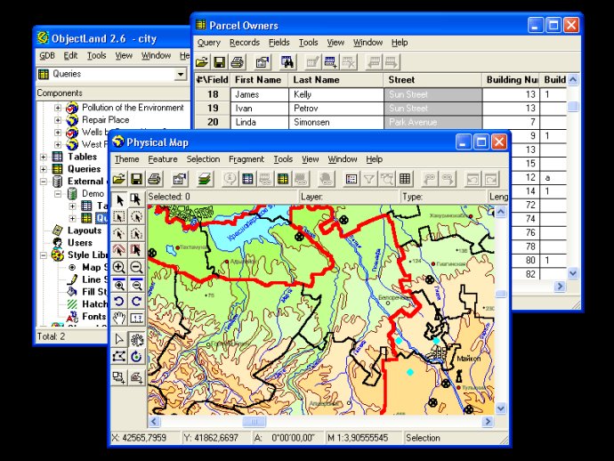
GIS ObjectLand
GIS ObjectLand Screenshot
Version 2.7.9
License Shareware $199
Platform Windows
Supported Languages English
System Requirements Standard PC
Free Version Limitations Noncommercial version
Homepage www.gis-objectland.com
Developed by Radom-IT
GIS ObjectLand is a powerful, universal Geographic Information System designed specifically for Windows. With a wide range of features and capabilities, this software delivers excellent performance in the creation of vector-raster maps that can be structured and customized as needed.

One of the key advantages of GIS ObjectLand is its compatibility with a variety of database management systems, including MS SQL Server, Oracle, DB2, MySQL, Interbase/Firebird, PostgreSQL, and MS Access. This means that users can easily and seamlessly integrate data from different sources into their maps and projects, regardless of the platform or format they use.

Other key features of GIS ObjectLand include the ability to create themes, or user presentations of a map, as well as advanced control over how features are displayed depending on the scale of the map. Users can input and edit spatial data through interactive drawing and by assigning feature coordinates, and can even sew separate pages of an imported map into a seamless, continuous map.

In addition to these capabilities, GIS ObjectLand provides powerful tools for copying, merging, and moving maps, layers, and feature types between different databases. Users can also create tables of arbitrary structure, and use queries to sort and search for data as needed. The software also supports a range of import and export formats, making it easy to work with data from different sources.

With style libraries, support for automation COM interfaces, and granular access permissions that allow users to tailor their experience to their needs, GIS ObjectLand is a flexible and customizable tool for all your spatial data needs. And with multiuser data editing and support for external databases via ODBC, it's the perfect solution for teams and organizations that need to collaborate across different systems and platforms.
What's New

Version 2.7.9: N/A

view map dxf table dbf gis theme layout CSV query mid Features SHP layer ObjectLand MIF cadaster cadastre cartography topography geodesy geomatics GDB geo
Free Download 28M
649
  • Share on:

Most Popular

  1. Database Tour 11.4.5.809
    93
  2. MS Access to MySQL Conversion Tool 4.0.6.5
    87
  3. MSSQL to MySQL Conversion Software Ex 5.8.3.1
    84
  4. SQLPro 2.1
    79
  5. MySQL Database To MSSQL Converter Ex 2.0.1.5
    77
  6. Easy Data Transform for Mac 1.0.0
    76
  7. Data Loader 4.9.8
    76
  8. Exportizer 10.1.3.590
    76
  9. MySQL DB to MSSQL Migration Tool 4.0.3.2
    75
  10. School Software Pack Pro 3.2b
    72

Related Downloads

MemDB Customer Relationship Management
Manage customer info, print cheques & envelopes, & send emails to customers ...
DecryptSQL
DecrypSQL is a software that helps users view complete SQL scripts on ...
MySQL Delete Duplicate Entries Software
Eliminate duplicate entries in MySQL tables with ease using this software. Select ...
MS Access Split Fields Software
This MS Access tool enables users to divide a single column into ...
PDB to DBF
The PDB to DBF converter can quickly convert standard PalmOS files (Palm ...
Paradox To Oracle Conversion Software
A software tool to transfer tables from Paradox to Oracle databases, it ...
OracleToAccess
OracleToAccess is a software that enables users to effortlessly import data from ...
Logicity
Crystal Reports software offers a powerful viewer and scheduler with administrative controls ...
Database Converters for OS X
This software allows you to easily convert Excel, SQLite, DBF and CSV ...
dbForge Event Profiler for SQL Server
DbForge Event Profiler is a free SQL Server tool that captures and ...
Copyright © 1999-2025 Softpile Free Downloads
  • Most Popular
  • Submit
  • About Us
  • Contact Us
  • Privacy Policy
  • Disclaimer
  • Terms of Use

Can we use your data to tailor ads for you?

Our partners will collect data and use cookies for ad personalization and measurement.

By choosing "I agree", closing this pop-up or clicking on any element on the page, you agree to the use of cookies to help us provide you with a better user experience.

Learn how Softpile and our partners collect and use data.

You can change your choice at any time in our privacy center.

Cookie Settings

Our website stores four types of cookies. At any time you can choose which cookies you accept and which you refuse. You can read more about what cookies are and what types of cookies we store in our Cookie Policy.

are necessary for technical reasons. Without them, this website may not function properly.

are necessary for specific functionality on the website. Without them, some features may be disabled.

allow us to analyse website use and to improve the visitor's experience.

allow us to personalise your experience and to send you relevant content and offers, on this website and other websites.