• Home
  • Most Popular
  • Submit
  • About Us
  • Contact Us

Softpile

Free Downloads

Categories
  • Home
  • Most Popular
  • Communications
  • Desktop
  • Games & Entertainment
  • Graphic Apps
  • Network & Internet
  • Security & Privacy
  • System Utilities
FreeFotoWorks 2025 25.1.0
This user-friendly software offers advanced photo editing features for effortlessly enhancing and achieving stunning clarity in ...
FotoWorks XL 2025 25.1.0
Fotoworks XL is a comprehensive photo editing software that offers a wide range of effects and ...
PhotoPad Pro Edition 14.25
PhotoPad Pro is a user-friendly Windows software for editing photos and applying special effects to improve ...
Aiseesoft AI Photo Editor 2.1.16
Aiseesoft AI Photo Editor is a powerful tool utilizing cutting-edge AI technology for image enhancement. With ...
Decoration 5.8
Decoration is a photo editing software that offers over 100 effects to enhance your images. With ...
Decoration For Mac 5.8
Decoration is a photo editing software with a range of 100 effects to add to your ...
Photo Pos Pro photo editor 4.14
Photo Pos Pro is a powerful photo editing software that enhances digital photos and enables users ...
ThunderSoft GIF Editor Pro 5.6.0
ThunderSoft GIF Editor Pro is a comprehensive software that includes a robust gif editor, gif maker, ...
Falco Announce Maker 14.6
Maker is a customer communication software that offers a quick and easy way to create announcements. ...
Falco Image Studio 22.1
Falco Image Editor is a user-friendly software tool that allows users to create and enhance images ...
Home Graphic Apps Editors RoboGEO Download

RoboGEO

February 25, 2012
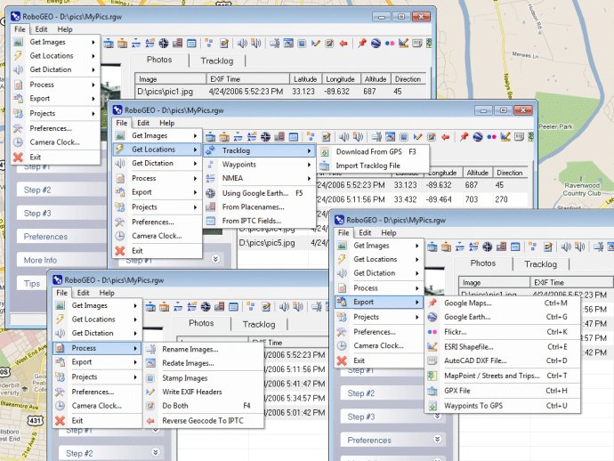
This software allows geocoding of digital photos with latitude and longitude values, with the option to stamp the images or write to the EXIF. The software can export to various formats including Google Earth, Google Maps, Shapefiles (SHP), AutoCAD DXF, GPX, Flickr and more. Additionally, the software supports importing all GPS tracklog formats and includes MGRS and UTM support.
RoboGEO
RoboGEO Screenshot
Version 6.3.2
License Demo $79.95
Platform Windows
Supported Languages English
System Requirements Windows XP/2000/Vista/Win7
Homepage www.robogeo.com
Developed by Pretek, Inc.
RoboGEO is an exceptional software that allows you to geocode your digital images with latitude, longitude, altitude, and direction information. The software enables you to stamp the mentioned information onto your images or write it to the EXIF, making it easy to permanently geocode and link your photos to GPS coordinates.

The software preserves all existing comments, including the MakerNote and the Adobe XMP metadata. It includes a Picasa-style geotagger for Google Earth, and you can also create web pages that use Google Maps. You can export KML or KMZ files to Google Earth, upload geotagged photos to Flickr, and export ESRI SHP shapefiles. Moreover, you can export to MapPoint or export DXF files to AutoCAD or IntelliCAD.

RoboGEO shows photo direction on maps and calculates it from the GPS tracklog. Additionally, you can merge EXIF or IPTC tags into the image titles and descriptions. If you record dictation using any modern digital voice recorder, the software automatically associates the audio with the photos. You can rotate or redate images based on the EXIF info, and you can export GPX files as well. It also allows you to edit the EXIF times and lookup altitudes, knowing only lat/lon. Photo locations can be projected to a new location in either ground or airplane mode.

RoboGEO is equipped with a free EXIF/IPTC viewer and can geocode any type of JPG, PNG, BMP, TIF, DNG, NEF, CR2, MRW, ERF, RAF, ORF, PEF, ARW, SR2, SRW, RW2, RAW, RWL, and MEF. It directly supports Garmin GPS units (USB or COM), but no GPS is required. The software can geocode images from a GPS tracklog, KML or KMZ files, NMEA sentences, waypoints, known place names OziExploer PLT files, or TCX files. You can also import GPX files for interfacing with other GPSs like Magellan and Trimble and import shapefiles.

With RoboGEO, you can rename images per the EXIF data and use the IPTC editor. The software also supports UTM and MGRS. You can use any digital camera and can be fully automated from the command line. It is the perfect tool for aerial photography, land surveyors, engineers, insurance claim adjusters, or anyone who needs to collect field data for integration into a GIS system. The software is affordable, comes with free lifetime upgrades, and has extensive documentation. The user interface is nice and very easy to use.
What's New

Version 6.3.2: Added Google Earth polygon file support and the ability to export HTML and enhanced the user-interface

photo image JPG raw exif dxf autocad gis GPS nmea dng geocode georeference geotag Flickr MapPoint Garmin DNR shapefile SHP KML KMZ latitude longitude tracklog waypoint GPX NEF CR2 MRW ORF ERF
Free Download 9.3M
703
  • Share on:

Most Popular

  1. eCut 5.0
    170
  2. Free Watermark Remover 6.0.0.4215
    126
  3. ASCII Art Generator 3.2.4.6
    126
  4. PhotoPad Pro Edition 14.25
    120
  5. Photo Pos Pro photo editor 4.14
    119
  6. FotoWorks XL 2025 25.1.0
    115
  7. ArtRage 5
    113
  8. Decoration 5.8
    113
  9. Glise 1.7.1
    112
  10. FreeFotoWorks 2025 25.1.0
    111

Related Downloads

360 Pano Viewer Lite
360 Pano Viewer Lite is a panoramic viewer that enables web users ...
AliveGlow Plugin
This software is a Photoshop plugin that offers a set of pre-built ...
Image Resizer by VSO
Image Resizer is a free software that can resize and convert images ...
T.Ed Pro Terrain & World Editor
T, Ed is a specialized tool for generating terrain meshes of various ...
FLIX99.COM - Watch Free Videos
FLIX99 is a popular video sharing platform where users can upload, view ...
Ripples Magic plug-in
Create stunning 3D surfaces with ease using this software. From cosmic curves ...
SWF To Image GUI
Easily convert .SWF files to JPG, PNG, or GIF formats with this ...
Network Diagram Maker
Network Diagram Maker is a versatile program for designing network topology diagrams. ...
Capturebox
Capturebox allows effortless sharing of files without folders, syncing, or waiting. Simply ...
AEC Buildings
This software provides tools for creating 3D CAD drawings from 2D designs ...
Copyright © 1999-2025 Softpile Free Downloads
  • Most Popular
  • Submit
  • About Us
  • Contact Us
  • Privacy Policy
  • Disclaimer
  • Terms of Use

Can we use your data to tailor ads for you?

Our partners will collect data and use cookies for ad personalization and measurement.

By choosing "I agree", closing this pop-up or clicking on any element on the page, you agree to the use of cookies to help us provide you with a better user experience.

Learn how Softpile and our partners collect and use data.

You can change your choice at any time in our privacy center.

Cookie Settings

Our website stores four types of cookies. At any time you can choose which cookies you accept and which you refuse. You can read more about what cookies are and what types of cookies we store in our Cookie Policy.

are necessary for technical reasons. Without them, this website may not function properly.

are necessary for specific functionality on the website. Without them, some features may be disabled.

allow us to analyse website use and to improve the visitor's experience.

allow us to personalise your experience and to send you relevant content and offers, on this website and other websites.