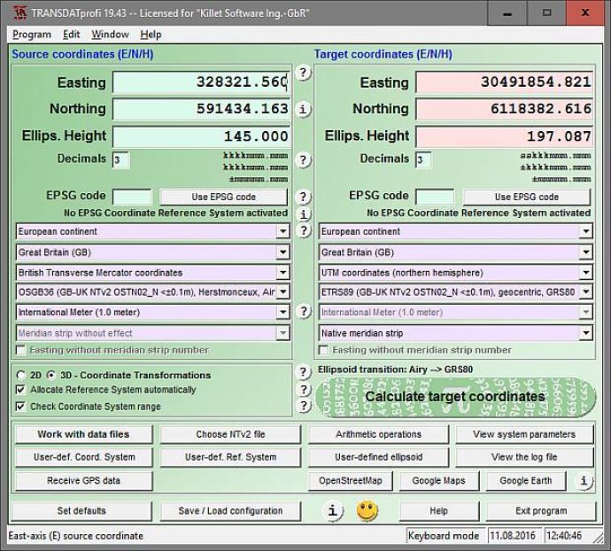
TRANSDAT is a software program that provides accurate coordinate transformation, supporting thousands of geodetic datum shifts and user-defined systems such as INSPIRE, NTv2, EPSG, and GPS. It also supports various file formats like CSV, Shape, KML, and GPX, making it a versatile tool for transforming coordinates.

One of the standout features of TRANSDAT is the ability to read and write various file systems, including Text, CSV, SDF, dBase, Arc-Shape, Arc-Generate, KML, GPX, and others. Additionally, the software offers outdoor GPS reception and mapping in popular platforms such as Google Earth, Google Maps, and OpenStreetMap. The inclusion of polygonal scopes in NTv2 files and a multilingual user interface also make this a highly flexible and user-friendly option.
TRANSDAT supports an impressive range of coordinate and reference systems. This includes current and historical systems of all countries in Europe, the European ETRS89 systems forced by INSPIRE, US and Canadian NAD, NTv2, HARN, and SPCS coordinate reference systems, as well as those of most countries on all continents, Germany, Austria, and Switzerland (including NTv2), and the old and new German Federal States, among others. The software can handle geographic coordinates in different notations and Cartesian coordinates, worldwide NTv2 gridfile supported coordinate transformations, and worldwide used numeric and alphanumeric coordinate systems.
For those who require even greater customization, TRANSDAT offers support for most of EPSG's supported coordinate reference systems, as well as ITRS annual realizations, WGS84 epochs for GPS measurements, user-defined coordinate systems, reference systems, and earth ellipsoids, and more. The software also includes features such as meridian convergence, origin center meridian, and geographical point coordinates.
As an example, Germany is broken down into several sub-groups, including the German "Lagestatus" coordinate reference systems, the high-precision reference systems of the German Federal States (including NTv2), and the 40 Soldner coordinate systems of the Prussian Land Registers. Overall, I was highly impressed with TRANSDAT's comprehensive capabilities and easy-to-use interface.
Version 23.05: Formatting of text, CSV and dBase files simplified and improved. Latest Helmert and NTv2 Reference Systems RDNAPTRANS2018 of the Netherlands. New Coordinate Systems (Google) Plus-Code / Open Location Code. CRS of many countries completed and adapted to EPSG version 9.6. ITRS 2014 realization added.
Version 22.23: New Coordinate System (Google) Plus-Code / Open Location Code. EPSG version 9.6. ITRS realization 2014 for ETRS89 and NAD83. New CRS Google World, Pixel and Tile Coordinates Zoom levels 0 - 23. Final NTv2 systems of Federal States Bavaria and Baden-Wuerttemberg. New tools for processing NTv2 files.
Version 22.15: ITRS Realisation 2014 für ETRS89 und NAD83 hinzugefügt. Neue CRS für Russland und für die Anliegerländer am Kaspischen Meer. Basis- und Profi-Editionen sind zum neuen TRANSDATpro zusammengefasst worden. Neue CRS Google Welt-, Pixel- und Kachelkoordinaten Zoomstufen 0 - 23.
Version 22.10: Basic and Professional Editions have been combined to new TRANSDATpro. New CRS Google World, Pixel and Tile Coordinates Zoom levels 0 - 23. Final NTv2 systems of the federal states Bavaria and Baden-Wuerttemberg. New NTv2 Reference Systems of Great Britain, Hungary and Venezuela.
Version 22.03: Final highly accurate NTv2 systems of the federal states Bavaria and Baden-Wuerttemberg. New NTv2 Reference Systems of Great Britain, Hungary and Venezuela. WGS84 (GPS) to ETRS89 und NAD83 (ITRSyear) complemented and refined. New CRS of Australia MGA2020 / GDA2020 with NTv2 support.
Version 21.18: New NTv2 Reference Systems of Great Britain, Hungary and Venezuela. WGS84 (GPS) to ETRS89 und NAD83 (ITRSyear) complemented and refined. New CRS of Australia MGA2020 / GDA2020 with NTv2 support. Highly accurate NTv2 system of the federal state Baden-Wuerttemberg.
Version 21.11: WGS84 (GPS) to ETRS89 und NAD83 (ITRSyear) complemented and refined. New CRS of Australia MGA2020 / GDA2020 with NTv2 support. Highly accurate NTv2 system of the federal state Baden-Wuerttemberg. Exchange and assign of the source and target systems. All Coordinate Reference Systems from Iceland.
Version 21.07: WGS84 (GPS) to ETRS89 und NAD83 (ITRSyear) complemented and refined. New CRS of Australia MGA2020 / GDA2020 with NTv2 support. Highly accurate NTv2 system of the federal state Baden-Wuerttemberg. Exchange and assign of the source and target systems. All Coordinate Reference Systems from Iceland.
Version 21.00: Highly accurate NTv2 system of the federal state Baden-Wuerttemberg. Exchange and assign of the source and target systems. All Coordinate Reference Systems from Iceland. New Coordinate System NAC-Code. New help topic "WGS84 / ITRS Epochs / Continental Drift". New file formats KML and GPX.
Version 20.59: New Coordinate System NAC-Code, (c) NAC Geographic Products Inc. New help topic "WGS84 / ITRS Epochs / Continental Drift". Meridian Convergence, Origin Center Meridian, Geographical Point. New file formats KML and GPX. New NTv2 systems for German Federal States Baden-Wuerttemberg and Bavaria.