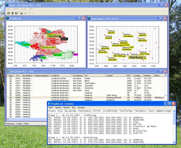
This software provides a database of geographical data including postal codes and vehicle registration numbers for Germany, Austria, Switzerland, and Belgium. It also allows users to create graphical representations of chosen locations through txt command files.

The "GEO" table provides various options for users, such as simple searches for any place by using any part of the postcode, place name, or memo. Users can also sort the table by any column by simply clicking on the column heading. Additionally, users can assign long remarks as memos to each location, and open and sort multiple tables simultaneously.
The "Map" window provides graphic representation of all locations with their specific features based on command files. Users can see all locations in Germany, Austria, Switzerland, and Belgium as dots on the map, and adjust the window size to change the map scale. Users can also open multiple maps and select a specific region by dragging a rectangle on the map. A new window then opens with a detailed view (including location names) of the chosen region. Once the user double-clicks any location on the map, a table with all locations near the clicked point opens.
The software also allows users to create graphic representations of their chosen locations in various ways by using command files. By assigning parameters such as state, postcode, start date, dot size, blink, main color, text color, text size, and text to any location, users can create multiple command files and open them simultaneously.
Overall, the software is a comprehensive database tool for users who need to access geodata in Germany, Austria, Switzerland, and Belgium, and it provides various ways to search, sort, and represent the data. The command file options also make it easier for users to customize their data visualization.
Version 1.1: No changes