• Home
  • Popular Downloads
  • Contact Us
  • Submit

Softpile

Free Downloads

Main Navigation
  • Home
  • Windows
  • Mac OS X
  • Business
  • Desktop
  • Development
  • Education
  • Games
  • Internet
  • Multimedia
  • Utilities
Home » Windows » Business » Applications » ORTWIN

ORTWIN

June 27, 2021
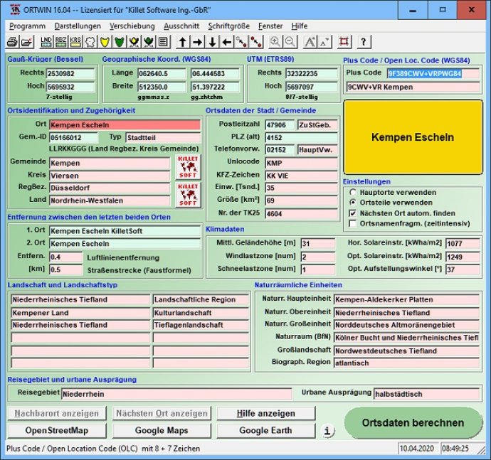
ORTWIN is a program for the inquiry of localities in Germany. It finds postal zip codes, telephone pre selections, coordinates. It performs perimeter searches and distance calculations. It finds landscapes, natural units, snow- and wind load zones.
ORTWIN
ORTWIN Screenshot
Version: 17.03
License: Free To Try $125.00
Operating System: Windows
Homepage: www.killetsoft.de
Developed by: Killet GeoSoftware Ing.-GbR
ORTWIN is a program for the state-wide inquiry of the localities, postal codes and telephone selections in Germany.

It finds postal zip codes, telephone pre selections, coordinates and ground level elevations.

The program determines municipal codes, local center points, car license codes, topographic maps, Unlocodes and much more.

It arranges localities hierarchically into the structures federal state, administrative district, rural district, town, municipality, local quarter and domicile.

The program performs perimeter searches and distance calculations. It finds landscapes on different levels, natural units and snow- and wind load zones of all localities.

In a radius around a place or around a postal code area covered localities and postal areas can be clearly represented by a comfortable perimeter search. They can also be arranged in a list, stored as a file and printed. For the local inquiries and perimeter searches a data base with more than 120.000 geo coded localities is available.

The program represents local data, determined by local inquiries and perimeter searches, in graphic overviews and data lists.

The program supports conversions between different coordinate systems and the distance calculation between the places.

It calculates with Gauss Krueger coordinates referring to the Potsdam Datum (Bessel ellipsoid, Rauenberg) and with Geographic Coordinates on the geodetic datum WGS84. It also works with UTM coordinates, which refer to the datum ETRS89 (GRS80, geocentric). The functionality of the program is described in a detailed electronic manual.

The program can be run on most common networks and it is possible to use Terminal Services on WINDOWS Servers. The client installations are done automatically.
What's New

Version 17.03: Program is faster and more stable using a new development system. All databases actualized on 1st. January 2021. Territorial Reform in Thuringia of the year 2019 implemented. View of localities in OpenStreetMap, Google Maps, Google Earth. Determining the wind load zones and snow load zones.

Version 16.00: All databases actualized on 1st. January 2019. Territorial Reform in Thuringia from 1.1.2019 taken into account. View of localities in OpenStreetMap, Google Maps, Google Earth. ORTWIN decorated with Innovation Award. Wind load zones and snow load zones. Travel areas and the solar radiation.

Version 15.00: Time-dependent message windows with countdown. All databases actualized on 1st. January 2018. Views in OpenStreetMap, Google Maps, Google Earth. ORTWIN decorated with Innovation Award from Innitiative Medium Businesses. Added wind load zones, snow load zones, travel areas and solar radiation.

Version 14.05: All databases actualized on 1st. January 2018. View of localities in OpenStreetMap, Google Maps, Google Earth. ORTWIN decorated with Innovation Award from Innitiative Medium Businesses. Determining the wind load zones and snow load zones. Determining the travel areas and the solar radiation.

Version 14.00: All databases actualized on 1st. January 2017. Digital signature for secure installation of the program. Determining wind load zones and snow load zones. ORTWIN wins Innovation Award 2016. View of localities in OpenStreetMap, Google Maps, Google Earth. Travel areas and solar irradiation added.

Version 13.00: Digital signature for secure installation of the program. Determining wind load zones and snow load zones. ORTWIN wins Innovation Award 2016. View of localities in OpenStreetMap, Google Maps, Google Earth. WINDOWS©10 certification after 32Bit / 64Bit test. Travel areas and solar irradiation added.

cities city coding coordinate coordinates distance district elevation geo index local locality municipality perimeter periphery place quarter register search town
Free Download 4.8M
0
  • Share on:

Sponsored

Categories

  • Applications
  • Business
  • Windows

Related Downloads

Flashnote
Flashnote is a quick notes manager for your quick work with any text ...
Geodata Germany
The database contain geodata of the Federal Republic of Germany with geo ...
Orbital's SQL Decryptor
Orbital's SQL Decryptor is a high quality, professional Microsoft SQL Server ...
Geodata International
Geodata International - World-wide database of countries with georeferenced ...
TOPOWIN
TOPOWIN is a state-wide register of the German topographic cartographies and of ...
Copyright © 1999-2017 Softpile Free Downloads
  • Contact Us
  • Submit
  • Privacy Policy
  • Disclaimer
  • Terms of Use