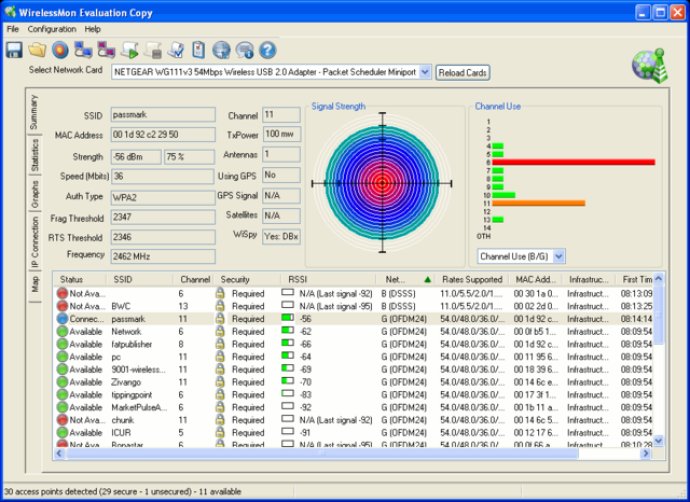
WirelessMon 2.0 software quickly identifies and tracks wireless networks, including unsecured access points and channel usage. Professionals can create a coverage map manually or with GPS, making it easy to track wireless networks.

One of the most impressive features of WirelessMon - 0 is its live ‘channel usage’ chart that provides information on the level of traffic for each available channel. This information is invaluable for network managers as it assists in indicating channels that could be used to reduce interference and improve throughput.
In addition, WirelessMon - 0 Professional Edition provides an additional bonus feature of generating ‘coverage maps’ based on the signal strength of all detected APs. To use this feature, users need to import a map created by another application (e.g., scanning). Once the map is loaded, users can either plot points manually on the map or use a Global Positioning System (GPS) device.
If users choose to plot manually, they can select a point on the map, and the program automatically stores information on every AP it can detect there. On the other hand, GPS users need to establish two reference points, and then the software will detect their location on the map and store the AP information for each point.
Network managers, laptop users, and wardrivers will all find WirelessMon - 0 to be the perfect tool for their wireless network requirements. With its many features and capabilities, the software provides an excellent experience for anyone who needs to monitor and manage a wireless network.
Version 5.0.1002:
Added support to display when a network is 802.11AC
Increased size of "Select AP" dialog window
Decreased memory use when saving a signal strength image
Fixed a display/synchronisation issue with the access point list
Improved information element processing
Version 5.0.1001:
Added support to display when a network is 802.11AC
Increased size of "Select AP" dialog window
Decreased memory use when saving a signal strength image
Fixed a display/synchronisation issue with the access point list
Improved information element processing
Version 4.0.1009:
Added support to display when a network is 802.11AC
Increased size of "Select AP" dialog window
Decreased memory use when saving a signal strength image
Fixed a display/synchronisation issue with the access point list
Improved information element processing
Version 4.0.1008: Fixed a crash that could occur in Windows7 and Vista when the OS reports a large number of network devices; Changed error message about missing network counters, WirelessMon will now automatically open the WirelessMon FAQ.
Version 4.0.1000: Added USB support for Garmin GPS. Added some extra messages when and if WirelessMon cannot load a map image due to memory limitations. Added import and export functions for MAC addresses when choosing access points to display on Map tab. Added right to left signal strength graph style on summary tab. Added "dropouts" count and column to summary view, tracks how often an access point is seen in one sample and lost in the next. Added KML (Google maps) log format options to access point and connected node logs. For more information visit http://www.passmark.com/products/wm_history.htm
Version 3.1.1003: Fixed a crash that could occur in Windows7 and Vista when the OS reports a large number of network devices; Changed error message about missing network counters, WirelessMon will now automatically open the WirelessMon FAQ.
Version 3.0 build 1001: New Mapping capability for geographical plotting of signal strength. GPS support added. Ability to connect to an access point directly from within WirelessMon. New real-time channel usage graph. SSID Filtering. Redesigned User Interface and new configuration options.
Version 3.0 build 1000: New Mapping capability for geographical plotting of signal strength. GPS support added. Ability to connect to an access point directly from within WirelessMon. New real-time channel usage graph. SSID Filtering. Redesigned User Interface and new configuration options.
Version 2.1 build 1001: New Mapping capability for geographical plotting of signal strength. GPS support added. Ability to connect to an access point directly from within WirelessMon. New real-time channel usage graph. SSID Filtering. Redesigned User Interface and new configuration options.
Version 2.0 build 1011: New Mapping capability for geographical plotting of signal strength. GPS support added. Ability to connect to an access point directly from within WirelessMon. New real-time channel usage graph. SSID Filtering. Redesigned User Interface and new configuration options.