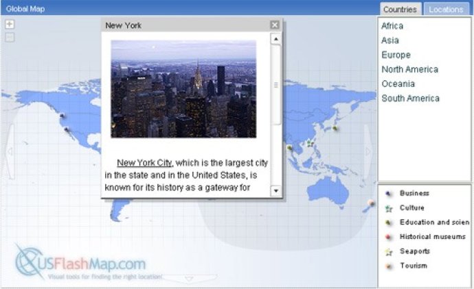
Our software, XML-driven World Map in Flash, offers a flexible and powerful solution for displaying business or personal data on a world map. With an intuitive design and convenient navigation tools, managing world countries and locations has never been easier.

One of the distinctive features of the main World Map is its customizable user interface and look-and-feel. With a simple configuration file, users can easily adjust the color gamma, navigation controls, and other interface parameters in just a minute, ensuring a perfect look on any web page or intranet interface.
The World Map in Flash is entirely XML driven, allowing users to integrate data easily and quickly. Whether it is setting up locations and areas manually or using any scripting language to import data from a database or spreadsheet (e.g., Excel / CVS), the software makes the process streamlined and straightforward.
Moreover, for interested users, the World Map in Flash offers a fully-featured 14-day free trial version available for download!
Users can take advantage of several unique features of the software, such as advanced navigation tools that include directional arrows and zoom controls. Additionally, the software supports small countries, islands, and territories and offers maximal zoom levels and custom zoom steps. Longitude/latitude location plotting (XY_Converter), unlimited numbers of locations, and location list and legend components are other salient features.
Users can attach photos, rich HTML description, and related events to present custom widgets for highlighting their data. The software also enables animated locations, location grouping, and provides location size control on zoom. Hide locations on the world view, add text to locations, and smoothly change the color on rollover to showcase the data more vividly.
The software boasts of a rich GUI control that comes with sound events and pop-up text on the mouse-over event. Additionally, hyperlinks facilitate web-links to additional or related resources, and users can create custom infobox titles, sizes, and position for every country or location they want. The usage of this software is possible on both internet and intranet, allowing for versatile applications.
Finally, users can control shape and outline color schemes as well as enable combining counties of data (dynamic regions) to have seamless maps from selected layers. The dynamic region and location outline clipping completes the feature-rich software package.
Version 3: N/A
Version 1.01: Easy to reach and click small countries