Affordable and user-friendly CAD surveying software with a comprehensive set of tools for accurate data analysis. Supports complex tasks like triangulation, contour mapping, volume calculations, and more. Efficiently handles large datasets while ensuring an intuitive experience for users.

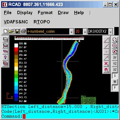
RTOPO comes equipped with its own specialized CAD system called RCAD, which is perfect for 3D work and supports a wide range of entities. With RCAD, you have access to various tools for loading and drawing points, interactive editing of XYZ files, point triangulation on a convex hull, and more. You can also create isolines (contour lines) and generate color-filled contour maps. In addition, cross sections and longitudinal profiles are supported, as well as the projection of multiple PLine entities over a triangulation.
Furthermore, RTOPO offers a variety of conversion tools. These tools enable you to convert a triangulation into a regular grid of points, convert existing isolines from maps into points and then into a triangulation, represent geological stratification from drilling data, and calculate 3D area, center of gravity, and volume between two triangulations or between a triangulation and a plan.
Other noteworthy features of this software include the ability to intersect and divide two triangulations or a triangulation by a horizontal plane, interpolation of 3DFACE entities using quartic triangular patches with G1 continuity, transformation of drawings containing entities like PLine, Line, Block, and Text into coded points and then into a triangulation, visualization of 4D point clouds, and the import and export of LandXML file types.
The RCAD CAD system, which is included with RTOPO, offers real-time orbit, pan, zoom, shading, lighting, and motion path animation features using OpenGL. Additionally, RCAD has a familiar command text area, graphics area, menus, and toolbars similar to other popular CAD systems.
Finally, RTOPO also includes script features that allow you to automate common tasks and save time.
In conclusion, RTOPO is an affordable and feature-packed CAD software that is perfect for surveying needs. With its intuitive interface, robust functionality, and compatibility with RCAD, it provides everything you need to efficiently handle complex surveying tasks.
Version 3.4: It can simulate rainwater runoff.
Version 3.3: It can be purchased with a 1-year subscription.