• Home
  • Most Popular
  • Submit
  • About Us
  • Contact Us

Softpile

Free Downloads

Categories
  • Home
  • Most Popular
  • Communications
  • Desktop
  • Games & Entertainment
  • Graphic Apps
  • Network & Internet
  • Security & Privacy
  • System Utilities
Exportizer 10.1.1.793
Exportizer is a simple and efficient software that enables users to quickly and easily export database ...
Database Tour 11.4.2.1504
Database Tour is a powerful software that simplifies database management. With features like viewing, editing, and ...
MS Access to MySQL Conversion Tool 4.0.6.5
MS Access to MySQL database migration software converts table structures attributes null values relationships with all ...
MySQL DB to MSSQL Migration Tool 4.0.3.2
Distributed database conversion program enables you to transform entire or selected source db tables (MySQL) to ...
MSSQL to MySQL Conversion Program 6.0.7.6
MSSQL to MySQL conversion software is a program used to convert entire or selected MSSQL database ...
dbForge Event Profiler for SQL Server 7.1
DbForge Event Profiler is a free SQL Server tool that captures and analyzes events. The data ...
dbForge Monitor for SQL Server 7.1
dbForge Monitor is a no-cost plugin for Microsoft SQL Server Management Studio. It enables users to ...
dbForge Data Generator for SQL Server 7.1
dbForge Data Generator for SQL Server is a GUI tool designed to quickly generate large amounts ...
Cisdem ContactsMate 2.0.0
Cisdem ContactsMate streamlines contact organization by consolidating information from multiple sources and enables editing and grouping. ...
MSAccess to MySQL Conversion 5.0.9.3
Automatically transfer entire .mdb or .accdb files from Microsoft Access to MySQL server using the Microsoft ...
Home Business Databases & Tools TOPOWIN Download

TOPOWIN

June 20, 2021
TOPOWIN is a topographic information system that serves as a comprehensive register for the German topographic cartographies and geo-referenced localities in various coordinate systems. It provides an efficient way to access and analyze topographical data across the country.
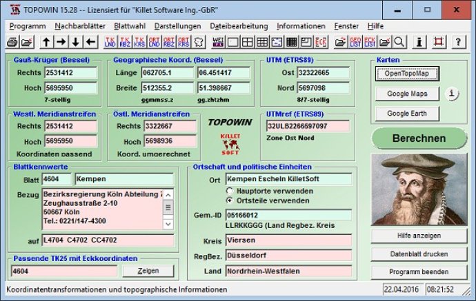
TOPOWIN
TOPOWIN Screenshot
Version 20.01
License Shareware $125
Platform Windows
Supported Languages English German
System Requirements Pentium, 50 MB HD
Free Version Limitations Full functionality up to 15 program starts
Homepage www.killetsoft.de
Developed by Killet GeoSoftware Ing.-GbR
The software TOPOWIN provides a state-wide register of the German Topographic Cartographies, the German Basic Cartography, and localities with geo references in different coordinate systems. It is a topographic information system that is frequently used in the division of planning and execution of economical and scientific projects.

This program is designed to make official topographic cartographies and the German Basic Cartography from the entire national territory easily accessible in suitable graphic views. TOPOWIN is capable of accomplishing different coordinate transformations and inquiries, thanks to the cooperation of the land surveying authorities of many German Federal States.

TOPOWIN is a useful and versatile tool for consulting engineers, planning authorities, and users of topographic maps. It allows topographical maps of different standards required for a project to be determined by entering known parameters or by directly selecting them from overview graphics and sorted lists.

Moreover, the program provides access to a data base with over 105,000 places and residential districts. By investigating topographical records on the basis of known locations, users can access this valuable resource.

TOPOWIN calculates with Gauss Krueger coordinates and Geographic Coordinates referring to the Potsdam Datum (Bessel ellipsoid with central point Rauenberg). It also works with UTM coordinates and UTMRef coordinates in the NATO standard, referring to the datum ETRS89 (GRS80 / WGS84, geocentric). This software is an indispensable tool for anyone seeking accurate and reliable geographic information.
What's New

Version 20.01: Program is faster and more stable using a new development system. All databases actualized on 1st. January 2021. Territorial Reform in Thuringia of the year 2019 implemented. View of maps in OpenTopoMap, Google Maps, Google Earth. All map views supplemented with UTM edge coordinates.

information map system measuring CORNER guide box geography topography place coordinate geodetics TK25 TK50 TK100 TKUE200 GK5 DGK5 geosoftware registers topowin topo placelist
Free Download 4.5M
1007
  • Share on:

Most Popular

  1. MS Access to MySQL Conversion Tool 4.0.6.5
    72
  2. dbForge Event Profiler for SQL Server 7.1
    53
  3. MSSQL to MySQL Conversion Software Ex 5.8.3.1
    52
  4. dotConnect for SugarCRM 2.3.190
    51
  5. MDB to CSV Converter 3.30
    51
  6. Exportizer 10.1.1.793
    51
  7. PostgreSQL to MySQL Converter 1.0.1
    50
  8. MySQL DB to MSSQL Migration Tool 4.0.3.2
    48
  9. PaGoDump for PostgreSQL 9.4.2
    48
  10. MySQL Database To MSSQL Converter Ex 2.0.1.5
    48

Related Downloads

Argentum Coolbase
Argentum Coolbase is a multi-purpose information manager software that uses a tree-like ...
List Remove, Compare & Duplicate Manager Software
This software allows you to load and manipulate lists. It can remove ...
FoxPro Append Two Tables Software
This software enables users to merge FoxPro tables vertically, regardless of whether ...
MS Access Editor Software
This MS Access table editing software lets users save tables as Text, ...
MySql to MSSql Database Migrator
The MySQL to MSSQL migrator tool quickly and reliably converts data between ...
Advanced ETL Processor Enterprise 32 Bit
This software provides the capability to create complex data warehouses and automate ...
CSV to DBF
This software converts CSV files to DBF format, supporting delimiters like TAB, ...
DBISAM to MS Access converter
This software allows the user to transfer DBISAM table records to Microsoft ...
OVO Backuper
OVO Backuper by OVOLogics is a robust tool that creates and restores ...
LEADS
LEADS and LEADS Pro are two versions of our reworked Sales Prospecting ...
Copyright © 1999-2025 Softpile Free Downloads
  • Most Popular
  • Submit
  • About Us
  • Contact Us
  • Privacy Policy
  • Disclaimer
  • Terms of Use

Can we use your data to tailor ads for you?

Our partners will collect data and use cookies for ad personalization and measurement.

By choosing "I agree", closing this pop-up or clicking on any element on the page, you agree to the use of cookies to help us provide you with a better user experience.

Learn how Softpile and our partners collect and use data.

You can change your choice at any time in our privacy center.

Cookie Settings

Our website stores four types of cookies. At any time you can choose which cookies you accept and which you refuse. You can read more about what cookies are and what types of cookies we store in our Cookie Policy.

are necessary for technical reasons. Without them, this website may not function properly.

are necessary for specific functionality on the website. Without them, some features may be disabled.

allow us to analyse website use and to improve the visitor's experience.

allow us to personalise your experience and to send you relevant content and offers, on this website and other websites.