• Home
  • Most Popular
  • Submit
  • About Us
  • Contact Us

Softpile

Free Downloads

Categories
  • Home
  • Most Popular
  • Communications
  • Desktop
  • Games & Entertainment
  • Graphic Apps
  • Network & Internet
  • Security & Privacy
  • System Utilities
UTM Coordinate Converter 2.0.4
UTM Coordinate Converter software converts different Geographic Coordinate Systems like Latitude/Longitude and UTM. It also displays ...
UTM Coordinate Converter Mac Silicon 2.0.4
UTM Coordinate Converter is a software that allows the conversion between different Geographic Coordinate Systems, such ...
UTM Coordinate Converter Mac Intel 2.0.4
The UTM Coordinate Converter is a software that allows users to easily convert between different geographic ...
NTv2Creator 2.09
The NTv2Creator software creates precise NTv2 files by comparing identical points in two distinct reference systems, ...
Maps Keeper for Google 1.0
This software is a user-friendly tool for creating customized maps based on Google Maps. It allows ...
OregonHotSprings.Immunenet.Com 1.0
Discover Oregon's top hot springs such as Bagby, Alvord, and Radium with our software guide. Explore ...
AW Geographical Atlas 3.0
The Atlas software provides detailed information about countries including location, population, economy, and military. It features ...
Home Education Geography NTv2Poly Download

NTv2Poly

June 16, 2021
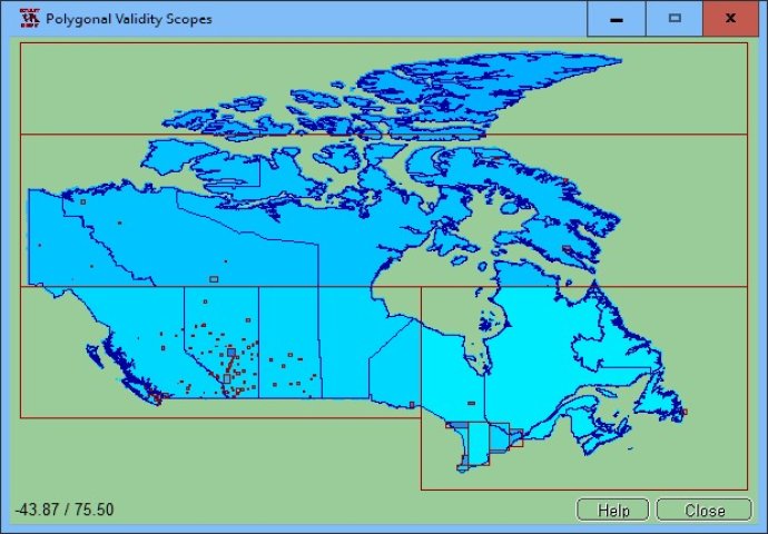
NTv2Poly is a spatial software that converts rectangular activity scope in NTv2 files into a Polygonal Validity Scope using a shape file. This replacement results in a more accurate representation of geographical areas.
NTv2Poly
NTv2Poly Screenshot
Version 4.02
License Shareware $185
Platform Windows
Supported Languages English German
System Requirements Pentium, 30 MB HD
Free Version Limitations Full functionality with presetted NTv2 files, full functionality upto 15 program starts
Homepage www.killetsoft.de
Developed by Killet GeoSoftware Ing.-GbR
If you're looking for a powerful spatial software solution, consider NTv2Poly. This software replaces the standard rectangular activity scope in NTv2 files with a Polygonal Validity Scope, which can be defined with an outline file in classic Shape Format. With this feature, invalid calculations that fall outside the Polygonal Validity Scope can be easily excluded or acknowledged with a warning.

To try out the software for yourself, simply download the trial version from our website. Once you're up and running, be sure to check out our detailed Worksheet to learn more about how to use NTv2Poly to its fullest potential.

One of the primary benefits of NTv2 files is that they provide incredibly accurate point transformations from one coordinate reference system to another. Each NTv2 file contains one or more coordinate grids that are defined in the NTv2 headers. However, many projects require more complex boundaries than a simple rectangle can provide. For example, you may need to create a quasi-polygonal area to cover a state territory within your country's borders.

Thankfully, NTv2Poly makes it easy to create these polygonal areas. By implementing Polygonal Validity Scopes in NTv2 files, coordinates that fall outside the validity scope can be automatically excluded from your calculations. This feature is compatible with a wide range of geospatial software, including TRANSDAT and GeoDLL, as well as many GIS programs that support Polygonal Validity Scopes.

To create a Polygonal Validity Scope, simply use a shape file that contains the outlines of the scope as polygons. The Shape file format, which was developed by ESRI, is an ideal format for storing geographical objects. For example, you can store the border outlines of a country in a shape file, which can then be used as the polygonal scope for your NTv2 file.

NTv2Poly is designed to make the process of overlaying polygons and rectangular surfaces easy and intuitive. The program comes with a user-selectable multi language interface and extensive online help, so you can get up to speed quickly. And because it can be run on most common networks and even supports Terminal Services on WINDOWS Servers, you can use NTv2Poly on practically any system.
What's New

Version 4.02: Program is faster and more stable with a new development system. New worksheet about the utilization of the program NTv2Poly. Added NTv2 and shape files from Canada and Germany for testing. Fixed problem processing of very large NTv2 and shape files. Added a new graphics window "Area Distribution".

file binary outline insert polygon shapefile Polygonal validity outlines shape ntv2 killetsoft scope inserting scopes ntv2poly
Free Download 10.5M
935
  • Share on:

Most Popular

  1. UTM Coordinate Converter Mac Intel 2.0.4
    41
  2. UTM Coordinate Converter Mac Silicon 2.0.4
    38
  3. OregonHotSprings.Immunenet.Com 1.0
    36
  4. NTv2Creator 2.09
    34
  5. NTv2Poly 4.02
    31
  6. Maps Keeper for Google 1.0
    31
  7. UTM Coordinate Converter 2.0.4
    31
  8. AW Geographical Atlas 3.0
    31

Related Downloads

OregonHotSprings.Immunenet.Com
Discover Oregon's top hot springs such as Bagby, Alvord, and Radium with ...
UTM Coordinate Converter
UTM Coordinate Converter software converts different Geographic Coordinate Systems like Latitude/Longitude and ...
UTM Coordinate Converter Mac Silicon
UTM Coordinate Converter is a software that allows the conversion between different ...
Maps Keeper for Google
This software is a user-friendly tool for creating customized maps based on ...
NTv2Creator
The NTv2Creator software creates precise NTv2 files by comparing identical points in ...
Copyright © 1999-2025 Softpile Free Downloads
  • Most Popular
  • Submit
  • About Us
  • Contact Us
  • Privacy Policy
  • Disclaimer
  • Terms of Use

Can we use your data to tailor ads for you?

Our partners will collect data and use cookies for ad personalization and measurement.

By choosing "I agree", closing this pop-up or clicking on any element on the page, you agree to the use of cookies to help us provide you with a better user experience.

Learn how Softpile and our partners collect and use data.

You can change your choice at any time in our privacy center.

Cookie Settings

Our website stores four types of cookies. At any time you can choose which cookies you accept and which you refuse. You can read more about what cookies are and what types of cookies we store in our Cookie Policy.

are necessary for technical reasons. Without them, this website may not function properly.

are necessary for specific functionality on the website. Without them, some features may be disabled.

allow us to analyse website use and to improve the visitor's experience.

allow us to personalise your experience and to send you relevant content and offers, on this website and other websites.