• Home
  • Most Popular
  • Submit
  • About Us
  • Contact Us

Softpile

Free Downloads

Categories
  • Home
  • Most Popular
  • Communications
  • Desktop
  • Games & Entertainment
  • Graphic Apps
  • Network & Internet
  • Security & Privacy
  • System Utilities
SpectrumSolvers 6.701
This software helps users choose the best Spectral Estimation Method for a Power Spectral Density plot, ...
NumXL 1.68.7.1
NumXL is an Excel add-in which streamlines financial modeling and time series analysis, making it simpler ...
Match n Freq 6.8
This software program helps to locate the pole-zero locations of a transfer function for a matched ...
FC Compiler 6.501
FC-Compiler is an advanced software for Calculus programming. It simplifies code using the FortranCalculus language for ...
XLSTAT 2022.4.5
XLSTAT is an Excel add-in that enables comprehensive data analysis and statistics with regression, multivariate analysis, ...
FFT Properties 6.4
Analyze long signals or Big Data with this time series and frequency spectrum analyzer software. Ideal ...
XLRISK 6.1.3.3
XLRISK, distributed by Addinsoft, simplifies the process of building and evaluating risk models with advanced Monte ...
OzGIS 14.7.0.7
OzGIS is a powerful geospatial data analysis software that enables efficient analysis and visualization of socio-economic ...
ThermalWall 3.0.0.0
ThermalWall is software that determines thermal properties of flat walls made of multiple homogeneous layers. It ...
SEVENPAR 11.04
SEVENPAR software precisely computes parameter sets for the Spatial Helmert/Molodensky transformation. This tool facilitates accurate coordinate ...
Home Business Math & Scientific Tools OkMap Desktop Download

OkMap Desktop

May 31, 2021
OkMap is a mapping software that organizes paths using custom waypoints, routes and tracks. It enables real-time GPS navigation and compatibility with vectorial and raster maps, including those scanned or purchased. It allows data upload and download to GPS devices.
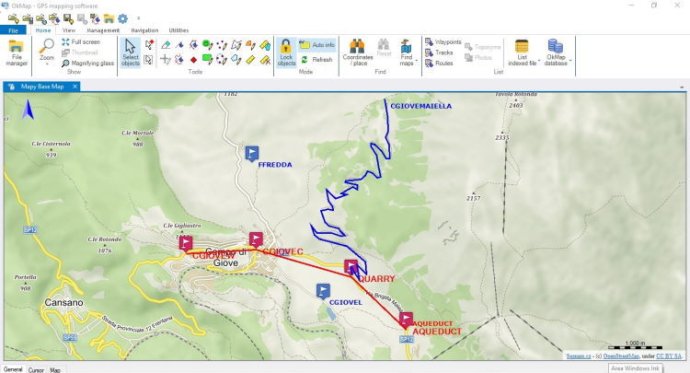
OkMap Desktop
OkMap Desktop Screenshot
Version 16.1.0
License Shareware $22
Platform Windows
Supported Languages English French German Italian Russian Slovenian Spanish
System Requirements Microsoft Framework 4.0
Free Version Limitations The maximum zoom value for web maps is limited to 12. ECW maps cannot be opened. Map georeferencing is limited to two points. GPX data cannot be saved. Download DEM data is not included. Map tiling is not included. The calculation of travel time ....
Homepage www.okmap.org
Developed by Gian Paolo Saliola
If you're in need of a powerful GPS software, OkMap is a great choice for all of your mapping needs. One of the best things about OkMap is that it works with both vectorial and raster maps, which can be calibrated to meet your specific needs. This means you can easily organize your paths by creating waypoints, routes, and tracks, and even upload/download data to/from your GPS device.

This software also uses altitude DEM data and supports GPS real-time navigation. You can easily send/receive vehicle positions and display tracks on maps in real-time. Additionally, OkMap provides autorouting and geocoding functions, making it easy to integrate with Google Maps/Earth (in 3D). With all of these features, OkMap is perfect for a wide range of potential uses, such as search and rescue, trekking, off-road exploration, boating, flying, mountain biking, geocaching, hunting and fishing, finding mushrooms, and soft air adventures.

OkMap has many powerful features that make it a great tool for anyone who needs to work with maps or GPS data. You can calibrate raster maps with different cartographic projections and even create your own digital maps by importing/drawing shapes. Additionally, you can create and manage waypoints, routes, and tracks in GPX format and download, save, and automatically georeference maps from Google Maps. OkMap also supports autorouting, geocoding, and inverse geocoding functions, and uses digital terrain models to store and display elevation.

This software also allows for easy data exchange and integration with other programs. You can upload/download data to/from GPS devices, navigate in real-time through NMEA protocol, and display Google Earth and Google Maps in your current map location. Additionally, you can exchange data with gpsgate.com server, receive navigation data from remote GPS devices, send the current position to an OkMap remote server, and make conversions between coordinates, datums, formats, and more.

OkMap supports a wide range of formats for images, maps, vector data, GPS data, and DEM data. For instance, you can work with images in formats like ECW, BMP, GIF, JPG, PNG, TIF, and more. Additionally, maps can be in formats like file world, ECW, GeoTiff, KML/KMZ, JNX, OziExplorer, CompeGPS, GPSTrackMaker, RMap, MBTiles, OruxMaps, GpsTuner, and more. You can also work with vector data in SHP and DCW formats, and GPS data in GPX, CompeGPS, EasyGPS, Fugawi, Garmin, Geocaching, Google Earth, GPS TrackMaker, OpenStreetMap, OziExplorer, and more. Finally, DEM data can be in HGT (SRTM-1 and SRTM-3) format. Overall, OkMap is an excellent GPS and map software that offers a wide range of features and capabilities for various needs.
What's New

Version 16.1.0: N/A

digital track raster nmea route georeference waypoint GeoCoding poi autorouting projection calibrate vectorial
Free Download 145.2M
688
  • Share on:

Most Popular

  1. Cut 1D X 3.6
    97
  2. Real Cut 2D 8.1.1.0
    96
  3. FLP Spreadsheet Solver 1.01
    93
  4. Functions 1.00
    62
  5. Free Number Generator 1.0
    56
  6. VIGraph 1.5
    56
  7. NumXL 1.68.7.1
    55
  8. DigitizeIt 2.5.9
    55
  9. WindRose PRO 3.1.71
    53
  10. DreamCalc Scientific Graphing Calculator 5.0.4
    53

Related Downloads

DigitizeIt
DigitizeIt software extracts (x,y) data from scanned graphs and converts into a ...
Cut 1D X
Cut 1D X automates the process of creating cutting designs for one-dimensional ...
StatFi 2009
StatFi is a cost-effective software that seamlessly integrates with Microsoft Excel to ...
PEEI
PEEI 4.0.0.1 software provides numerical solutions for all solvable partial differential equations ...
BioStat 2009
BioStat 2009 is user-friendly statistical software tailored for biology and medicine. Its ...
FFT Properties
Analyze long signals or Big Data with this time series and frequency ...
ISBH
InnerSoft ISBH is a software that calculates the soil water balance and ...
DoseTrade
DOSE software increases profits and reduces holding costs by boosting sales. It ...
SO-Log
SO-Log is geotechnical software that generates comprehensive borehole logs, summarizing the tests ...
SO-Unconfined
SO-Unconfined is an evaluation software for unconfined compression tests, featuring a user-friendly ...
Copyright © 1999-2025 Softpile Free Downloads
  • Most Popular
  • Submit
  • About Us
  • Contact Us
  • Privacy Policy
  • Disclaimer
  • Terms of Use

Can we use your data to tailor ads for you?

Our partners will collect data and use cookies for ad personalization and measurement.

By choosing "I agree", closing this pop-up or clicking on any element on the page, you agree to the use of cookies to help us provide you with a better user experience.

Learn how Softpile and our partners collect and use data.

You can change your choice at any time in our privacy center.

Cookie Settings

Our website stores four types of cookies. At any time you can choose which cookies you accept and which you refuse. You can read more about what cookies are and what types of cookies we store in our Cookie Policy.

are necessary for technical reasons. Without them, this website may not function properly.

are necessary for specific functionality on the website. Without them, some features may be disabled.

allow us to analyse website use and to improve the visitor's experience.

allow us to personalise your experience and to send you relevant content and offers, on this website and other websites.