• Home
  • Most Popular
  • Contact Us
  • Submit

Softpile

Free Downloads

Categories
  • Home
  • Most Popular
  • Communications
  • Desktop
  • Games & Entertainment
  • Graphic Apps
  • Network & Internet
  • Security & Privacy
  • System Utilities
Home Desktop Other ediTrail

ediTrail

November 7, 2014
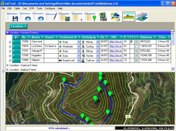
This software allows users to effortlessly create, edit, display, and manage trails and routes. The user interface is simple and flexible, featuring data tables for trail management and integration with popular mapping providers such as Bing, Arcgis, Ovi, and Yahoo. Importing and exporting capabilities are also included.
ediTrail
ediTrail Screenshot
Version 1.0
License Freeware
Platform Windows
Supported Languages English Spanish
Homepage www.editrail.com
Developed by Aplicaciones Topogrficas S.L.
This software provides users with a range of helpful features for importing and exporting trails to GPX files. With an unlimited number of trails and TrackPoints, users have the ability to export to GPX, Excel, PDF, XPS, and KML/KMZ. One of the standout elements of this software is the flexible data table, which allows for sorting by columns and inheritance of data, attributes, and much more.

The presentation on the map is another key feature of this software, which displays maps in accordance with the active trail. This includes provider maps such as 'Satellite' mode (photos, orthophotos, etc) and 'Map' mode (Topographic map, street maps, etc). The digital terrain model (DTM) is also included with the software, offering users the ability to download all files, patches, with elevations of a point every 90 metres from around the world and 30 meters for the United States, (DEM, digital elevation model), taken by the 'Shuttle Radar Topography Mission', SRTM.

Additionally, the software offers a longitudinal profile tool, allowing users to view profiles with direct and reciprocal relationships with the TrackPoints and WayPoints of the active trail. Users also have access to a powerful trail editing tool, which allows for the creation, modification, joining, splitting, and deleting of trails graphically. All of these actions can be completed with the click of a button on the map.

With regards to display and management of photographs, the software includes an image viewer that allows users to easily view and rotate photographs as needed. Furthermore, the software works seamlessly with AutoCAD/Bricscad/ZWCad, allowing users to draw trails, waypoints, digital models, maps, contouring, and a cloud of points within these software platforms. This enables users to have their trail in UTM XYZ WGS84 coordinates, allowing for inclusion of new maps of any active WMS service, (Warehouse Management System), and above all, with CAD tools.
What's New

Version 1.0: New version

photo map track GPS route latitude longitude GPX utm elevation trail land Surveying Terrain geographical hiking biking cycling
Free Download 27M
241
  • Share on:

Related Downloads

PicWheel
This software updates desktop wallpaper with various picture formats and auto-scales them for optimal display. It offers versatile list and schedule management in English ...
7art Mirror Clock ScreenSaver
7art Mirror Clock is a software that allows users to turn time back by having its hands move backwards and bringing new time that ...
Basketball Predictor
Revolutionary software using advanced neural network algorithms can accurately predict Basketball game outcomes, making it an invaluable tool for sports bettors who want to ...
LuxNow
LuxNow
LuxNow is an Android app that allows you to quickly measure the ambient light levels using your device's light sensor. With a simple tap, ...
Turbo VPN
Turbo VPN
Turbo VPN is a free and unlimited VPN software that offers a secure, reliable, and super-fast network for accessing your favorite content anonymously. It ...

Don't Miss

Copyright © 1999-2023 Softpile Free Downloads
  • Most Popular
  • Contact Us
  • Submit
  • Privacy Policy
  • Disclaimer
  • Terms of Use

This website uses cookies

By choosing "Accept all cookies", closing this pop-up or clicking on any element on the page, you agree to the use of cookies to help us provide you with a better user experience and to analyse website usage.

By clicking "Adjust your preferences" you can choose which cookies to allow. Only the essential cookies are necessary for the proper functioning of our website and cannot be refused.

Cookie Settings

Our website stores four types of cookies. At any time you can choose which cookies you accept and which you refuse. You can read more about what cookies are and what types of cookies we store in our Cookie Policy.

are necessary for technical reasons. Without them, this website may not function properly.

are necessary for specific functionality on the website. Without them, some features may be disabled.

allow us to analyse website use and to improve the visitor's experience.

allow us to personalise your experience and to send you relevant content and offers, on this website and other websites.